Wednesday, May 8, 2013

Climate Change


Climate Change in Afghanistan:


                Afghanistan has a rugged climate and is mostly a dry country and mountain landscape.  80 percent of the population directly depends on the already scarce natural resources.[1]  Afghanistan depends on the glaciers in the mountains to provide a steady water supply for all life to be inhabitable in the country.  It is believed by the year 2030 the annual temperature will have increased by .06 degrees Celsius from 1960 along with spring rainfall to have decreased by close to 2.7 mm per month.[2]  Models point towards an increase in temperature all across Afghanistan with a possible increase up to 6 degrees Celsius by 2090.[3]  Other models project an increase in temperature by 1.4 to 4.0 degrees Celsius by 2060 and by 2090 an additional increase of 1.5 to 2.5 degrees Celsius.[4]

 
In 1,000 Years:
                Based off this information in 1,000 years we can see a steady climate change in Afghanistan.  With lower amount of rainfall and a rise in aquaculture people would be forced to move away from more rural areas due to lack of water.  This is already being noticed by the Amu Darya River’s due to the expansion of irrigated lands the river failed to reach the Aral Sea in the late 1980’s.[5]   The Glaciers in the mountains would have greatly decreased and have melted forming a greater number of glacier lakes.  Using Satellite-based assessment of glacier termini positions and looking at the data pulled from August 1976 to July 2003 the glacier retreated with an average distance of 294 meters.[6]  Assuming on average the glaciers are reduced by 294 meters every 25 years by the year 3013 the glaciers in the mountains of Afghanistan would have decreased in size by 1,168 meters or about 3,832 feet.

In 10,000 Years:
                In 10,000 years the glaciers will be reduced by 11,680 meters which is about 7 miles in circumference.  Afghanistan has more than 3,000 small mountain glaciers in the Hindu Kush and Pamir mountains that provide water to the region.  China which has a larger area contains a 22,944 square miles of glaciers.[7]  Afghanistan having a smaller square mile coverage will be greatly affected by this.  At this point a large body of the glaciers would have formed into glacier lakes in the mountains.  This will reduce the water throughout Afghanistan making it very difficult for any agriculture to take place or support any large amount of population.
 

In 100,000 Years:
                In 100,000 years if things continue on this pattern all of the glaciers in Afghanistan would be completely gone.  With the dry climate the glacier lakes would also be a thing of the past.  Without this source of water Afghanistan would become an uninhabitable barren landscape incapable of maintaining life.  There are already large areas within Afghanistan that resembles such desolate surroundings.

                Afghanistan is in the process of joining Kyoto Protocol to the UNFCCC (United Nations Framework Convention on Climate Change) which is in international treaty that forms binding obligations on industrialized countries to reduce emissions of greenhouse gases that will take place on June 23 of 2013.[8]  Based off the data it will be thousands of years before noticeable effects on Afghanistan’s climate will be changed.
Image sources:


Work Cited:


[1] http://programs.wcs.org/afghanistan/Challenges/ClimateChange.aspx
[2] http://programs.wcs.org/afghanistan/Challenges/ClimateChange.aspx
[3] http://programs.wcs.org/afghanistan/Challenges/ClimateChange.aspx
[4] http://www.necsi.edu/afghanistan/pdf_data/2007447_AfghanCC_ExS_09MAR09.pdf
[5] http://programs.wcs.org/afghanistan/Challenges/ClimateChange.aspx
[6] http://www.glims.org/glacierdata/data/lit_ref_files/haritashya2009.pdf
[7] http://content.usatoday.com/communities/sciencefair/post/2010/08/asias-glaciers-in-reteat-could-signal-crop-failure-and-flooding-in-the-future/1
[8] http://www.rtcc.org/afghanistan-joins-kyoto-protocol/

Wednesday, April 17, 2013

Sandstorms


What is a Sandstorm:

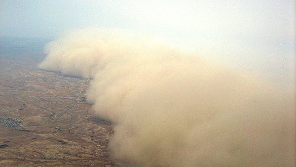
     Sandstorms (also known as Dust storms) is when high winds touches and picks up loose sand or soil and moves it throughout the air causing poor visibility and sometime even blackout conditions.1  Within such storms the sand can cause large amounts of damage including covering agriculture creating famine, death to livestock and people if exposed in a storm and damage to property such as transportation vehicles. 


Masks are important if caught outside during a sandstorm to help prevent breathing in sand particles.


How are Sandstorms Formed:

     Sandstorms usually take place in dry hot places and are more likely to occur during the summer.  This is because there is a high level of heating within the air over barren landscapes such as deserts that cause the lower atmosphere to become unstable.  With the atmosphere being unstable causes a mixture of strong winds in the middle troposphere to move downward to the surface.  In a result produces strong winds that lower to the surface.2   In deserts in dry hot climates like in Afghanistan creates a higher possibility for sandstorms to take place. 


Sandstorms Affecting Afghanistan People:


     Sandstorms are a major threat to the people of Afghanistan with the possibility of destroying crops, contaminating water supplies and the potential of destroying homes.  In 2003, more than 12,000 people 57 villages which were seriously affected by sandstorms which were recorded by the United Nations.3  In one of the more sever sandstorms “up to 20 villages had to be evacuated because they were covered in sand which was banked up against the walls of homes and compounds.”4 Sandstorms such as these would not only create displaced families but they will also have to rely on a limited amount of water and food supply’s that were not affected. 
 
3.http://www.irinnews.org/Report/20553/AFGHANISTAN-Sandstorms-affect-over-ten-thousand-people
4.http://www.irinnews.org/Report/20553/AFGHANISTAN-Sandstorms-affect-over-ten-thousand-people


Work Cited:
1.http://www.weatherquestions.com/What_causes_sandstorms.htm
2.http://www.weatherquestions.com/What_causes_sandstorms.htm
3.http://www.irinnews.org/Report/20553/AFGHANISTAN-Sandstorms-affect-over-ten-thousand-people
4.http://www.irinnews.org/Report/20553/AFGHANISTAN-Sandstorms-affect-over-ten-thousand-people

Image Source:
 
1.https://plus.google.com/photos/110851263651500394524/albums/5838707893829761569/5867997542086214962
2.http://www.guardian.co.uk/world/2011/feb/06/al-qaida-afghanistan-peter-bergen-review
3.http://www.weatherquestions.com/What_causes_sandstorms.htm
4.http://op-for.com/2009/07/the_wolfpack_3d_lar_in_iraq.html
6.https://plus.google.com/photos/110851263651500394524/albums/5838707893829761569/5868038530524804354

Monday, March 11, 2013

Afghanistan Landscape


Afghanistan Soil:


Most of the landscape is baron and is contains the images of the desert.  Since the only source of water comes from rivers from the mountains and a handful of lakes make the soil conditions are formed under arid and semi-arid climate conditions.[1]  Loam being the soil concentration of sand, silt and clay Afghanistan soil itself contains ranges from mostly clay loam to sandy loam.  There is a high soil ph and calcium carbonate contents, however the organic matter content only ranges from 0.2 to 0.25%.[2]


Classification:
Afghanistan generally falls under Aridisol which is characterized by the lack of available water.  In Aridisol landscapes there is a process known as Calcification in which calcium salts build up in soft tissue causing it to harden.[1] 


There is a little to no O or A Horizon.
Ranging from 0.2 to 0.25% 
 
No E Horizon
 
B Horizon is generally the first layer in this area.  This is where calcium carbonate accumulates.
 
K Horizon which is only found in Arid soil zones.
This is a mineral horizon of caliche which is usually extreamly hard.
 
The C Horizon is part of the earth lacking in organic matter.  Also known as Regolith it includes typically dust, soil, and broken rock.[1]


What this means for the people:
 
     Despite the harsh surface in most parts of Afghanistan the soil in all is typically rich with nutrients.  In areas close to constant water source is lush and green.  This is important when herding livestock of lambs, sheep, cattle and other such animals.  Farmers also need a steady water source but they also use different kind of fertilizers such as “white” fertilizer and Diammonium Phosphate. In many cases fertilizer from livestock was used and even humans which is commonly known as “night soil”.[1]  When I was in Afghanistan I remember the military having difficulty convincing the farmers to grow crops other then hemp.   Cannabis being a legal plant in Afghanistan was simply the crop that paid the most and was not controlled by any drug cartel or war faction.


Image sources:
 
1.  Photo taken by Craig Brice around 2006
2.  Photo taken by Craig Brice around 2006
4.  Photo taken by Craig Brice around 2006
5.  Photo taken by Craig Brice around 2006
6.  Photo taken by Craig Brice around 2006


Tuesday, February 12, 2013


The Central Highlands:

            When most people think of the physical geography of Afghanistan the first thing that usually comes to mind is the mountain region.  This is largely due to the fact that 160,000 of the 250,000 square miles are covered by the highlands.[1]  The main mountain range in Afghanistan is the Khyber Pass which is also part of the Hindu Kush Himalayan region.  This mountain region expands across eight other countries and contains some of the largest mountains in the world.[2]  The mountains in Afghanistan are relatively small where the largest peak reaches 7,492 meters with Mount Noshaq.[3]


How were they formed:

            Afghanistan is located between the Eurasian Plate and the Indian Plate.  Earthquakes and active faults by the colliding of these plates form the mountains in this region. [4]  Afghanistan has been on the Eurasian Plate for around 250-350 million years.[5]  At a speed of 3.9 cementers a year the Indian Plate is being pushed underneath the Eurasian Plate causes land to rise forming the mountains in this region.[6] This plate tectonic interaction is known as a convergence style between the two plates.


What this means for Afghanistan:

            Afghanistan is a land locked country in a harsh barren environment.  Almost all sources of water available for this country comes from the rivers formed that come off the mountains.[7]  Without this source of water living in Afghanistan would be nearly impossible.  When I was staying in Afghanistan I was surprised how green areas were and how dead and barren others even though they were only a short distance between each other.  The stretch of rivers allows life to be possible in Afghanistan.  The mountains also provide defense for the people of Afghanistan where its history shows that because of these mountains no country has ever successfully occupied it.


Image sources:
Image 1:  Photo Taken by Craig Brice in 2006.
Image 4: Photo Taken by Craig Brice in 2006.
Image 5:  Photo Taken by Craig Brice in 2006.
Image 6:  Photo Taken by Craig Brice in 2006


[1] http://www.afghan-web.com/geography/lr.html
[2] http://www.icimod.org/?q=1137
[3] http://www.icimod.org/?q=1139
[4] http://civil.neduet.edu.pk/tp.html
[5] Russel Wheeler and Kenneth Rukstales USGS 2007, http://pubs.usgs.gov/of/2007/1104/OF7-1104-textonly_508.pdf
[6] Russel Wheeler and Kenneth Rukstales USGS 2007, http://pubs.usgs.gov/of/2007/1104/OF7-1104-textonly_508.pdf
[7] http://geography.howstuffworks.com/middle-east/afghanistan-geography1.htm

Tuesday, January 29, 2013

Geographic Afghanistan


Introduction to Afghanistan:

This is my blog for Physical Geography 1202 created by Craig Brice.

    I lived in Afghanistan in August of 2005 to May of 2006 where I spent the year traveling around the country meeting new people and seeing the different parts of landscapes within the country.  I spent most of my time in the south east region of Afghanistan where I was escorting and patrolling the region along Pakistan.


   Land Features of Afghanistan:

In my time in Afghanistan I was surprised at all the different amount of landscapes I came a crossed and how fast the environment would change.  I had heard stories of the Hindu Kush Mountains in Afghanistan which takes up about two thirds of the countries mass of the Central Highlands.[1] I had also become accustomed to the deserts within the Middle East including the South Western Plateau, but also areas away from water.  I was surprised on how green parts of the country was not just including the Northern Plains area which has the most fertile land in the country.[2]  One can easily see a large abundant of life near rivers and a short distance away the surroundings return to a harsh lifeless desert.


   It is my hopes to learn more about these features in the beautiful country most people will never get to experience.  There is so much unknown to the general public about this country that I would like to shine some light on the greatness of Afghanistan that in its past has been surrounded with so much negativity.  This is the journey I hope to uncover and share in my pursuit of the geographic world of Afghanistan.


Image Sourcas:
 
Imagae 1:  Photo taken by Craig Brice 2006
Image 3:  Photo Taken by Craig Brice 2006
Image 4:  Photo taken by Tim Brown 2006